Hot weather returns with storms
A few strong storms are possible for the middle of this week with hot & humid conditions. A heat wave is expected next week.
Share:
More Stories
1:24

Stormy pattern this week in the Hudson Valley
2ds ago1:24

Wet start to the week in the Hudson Valley; sunshine returns midweek
9ds ago1:16
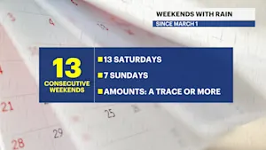
Streak of weekends with rain set to continue for lower Hudson Valley
15ds ago1:24

Sunny and clear Monday in the Hudson Valley before temps soar later this week
16ds ago1:24

Memorial Day weekend ends with beautiful evening in the Hudson Valley
22ds ago
News 12 weather blog
32ds ago1:24
Stormy pattern this week in the Hudson Valley
2ds ago1:24
Wet start to the week in the Hudson Valley; sunshine returns midweek
9ds ago1:16
Streak of weekends with rain set to continue for lower Hudson Valley
15ds ago1:24
Sunny and clear Monday in the Hudson Valley before temps soar later this week
16ds ago1:24
Memorial Day weekend ends with beautiful evening in the Hudson Valley
22ds agoNews 12 weather blog
32ds agoThis morning is muggy with dense fog in Westchester County and a few passing downpours. The heat and humidity build today and peaks on Thursday. A pop-up strong storm is expected Thursday afternoon. Friday and Saturday look pleasant. There is a risk for passing showers on Sunday which will bring the risk for extreme heat Sunday, Monday, Tuesday, and next Wednesday.

FORECAST
TODAY: Bring an Umbrella
It's not a washout but pop up downpours are likely this morning and possible this afternoon. Humid with highs near 80, feels like mid-80s.


THURSDAY: Very Hot & PM Strong Storms
Thursday likely starts off dry with temperatures in the 70s & 80s in the morning. Expect sun & clouds with highs in the low 90s, feels like mid or upper 90s with the humidity. Pop up storms are expected after 2 PM and as late as 8 PM. A few storms could produce damaging wind and heavy rain.


FRIDAY: Pick of the week!
Mainly sunny and less humid. Morning temperatures 60s & 70s with afternoon highs in the mid-80s.
SATURDAY: Hot but Dry
Sunny skies in the morning with a mix of sun and clouds in the afternoon. Highs in the upper 80s.
SUNDAY: Hot & Cloudy
Humidity and heat build with highs near 90 degrees. It's mainly cloudy with rain possible early in the day. Feels like 95F.
EXTREME HEAT NEXT WEEK:
Hot & Humid weather is likely next Monday through Wednesday. Temperatures will reach the 90s each afternoon and will feel like 100 degrees on Tuesday.


More from News 12
1:24
Stormy pattern this week in the Hudson Valley
1:24
Wet start to the week in the Hudson Valley; sunshine returns midweek
1:24
Sunny and clear Monday in the Hudson Valley before temps soar later this week
1:24
Memorial Day weekend ends with beautiful evening in the Hudson Valley
News 12 weather blog
1:24
